Table of Contents
Introduction:
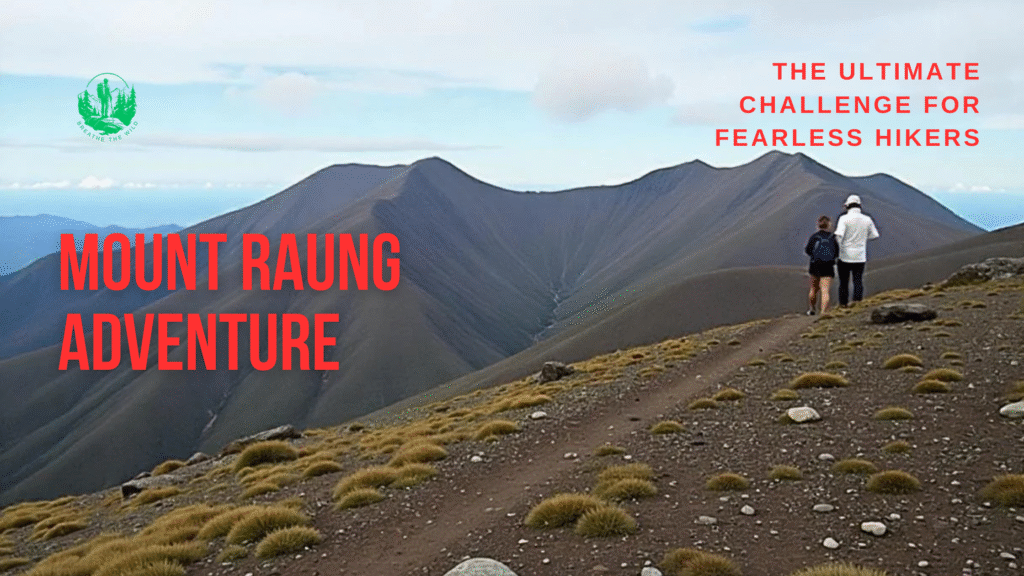
Mount Raung is surprising because it is not a regular mountain; it is an endurance, a strength, and a mental challenge hidden deep in the craggy mountains of East Java. It is an active stratovolcano more than 3,344 meters above sea level, and only the boldest hikers would dare wander along the jagged crater rim and the unpredictable terrain. However, unlike many other volcanoes that get tourists like Bromo or Ijen, which are more accessible, Mount Raung is wild, difficult to get to the top of with an ascent to its highest peak that will test and reward hikers with a view that cannot be compared to almost anything els,e and the sense of geologic enormity.
It is a straightforward and adventurous escapade. Sharp slopes across the woodland forestst, as well as ridge narrows exposed to the elements, are just a few of the things that one has to be prepared, physically fit, and bold-headed when hiking Mount Raungg. But to those who dare to make the effort, the results are well worthwhile — to see the sun rise through the jagged edge of its mammoth, billowing crater is something that can never be forgotten.
And the final word being, in this section, we will take you through all you need to know about hiking Mount Raung, how you can get there, the things to carry, and the correct trail to follow, as well as safety precautions. You may be a hardcore mountaineer or an adventure junkie having your next big adventure in mind, but the hike up Mount Raung is a bucket-list item, and it is not a journey where one can dare to compromise with any of the three sensations: danger, beauty, and thrill.
Where Is Mount Raung? Location, Access & Base Points
Mount Raung is an elevated volcano in the corner of the Southeast Indonesian island of Java, which is quite distinct due to the collision of Banyuwangi, Bondowoso, and Jember regencies. It is therefore among the most dramatic and exhaustive volcanoes in the locality. It is quite an out-of-place place whose hilly terrain and green grassland contribute even more to the wilderness feature.
The access is also an adventure in itself in reaching Mount Raung. The most common of them is that which starts in Surabaya, the capital of East Java. Train or bus: In Bondowoso, one can reach all the access cities (Bondowoso, Banyuwangi, or Jember) by train. Banyuwangi has a special interest among hikers because it is located nearby and the infrastructure around the location is developed. This may be pursued in a car or local transport to one of the base villages.
There are two starting points that are most popular to climb Mount Raung, in Sumberwringin, Bondowoso, and Kalibaru, Banyuwangi. Even more traditional and even more popular one is Sumberwringin, which perceives it as the entrance to the popular path to the top. It is necessary to add that it is common to organize travel permits, guides, and porters who have to sort around these base villages.
The Legendary Trek: What It’s Like to Hike Mount Raung
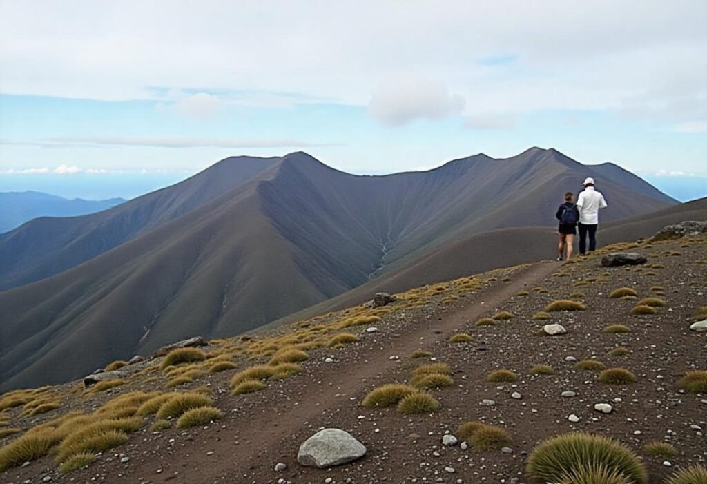
The trek on Mount Raung is a trek in itself, but we should say an epic adventure. The climb in Sumberwringin through a somewhat rocky pathway through thick forest and wet jungle tracks would be the starting point for the majority of the hikers to steep volcanic slopes. It is a notable task due to the need for strong endurance and courage in the expedition.
One hike takes 14-20 kilometers, round trip, and the highest point is 3,344 meters above sea level. The hike usually takes a period of 2 to 3 days unless the weather, pace, and the number of individuals involved are altered. There is dramatic lifting, loose volcanic gravel, and thrilling along the trail that either has you climbing over rocks or fighting to make it along slippery ledges.
Camps are also largely established in predetermined areas in the course as well and most of the treks start during the sunrise times. With every step that leads up the hill, you are deeper into one of Java’s wildest landscapes– off-grid and in incredulous paradise.
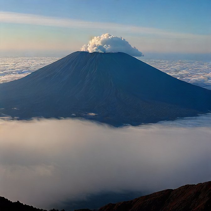
Reaching the Crater Rim: Adrenaline and Views Like No Other
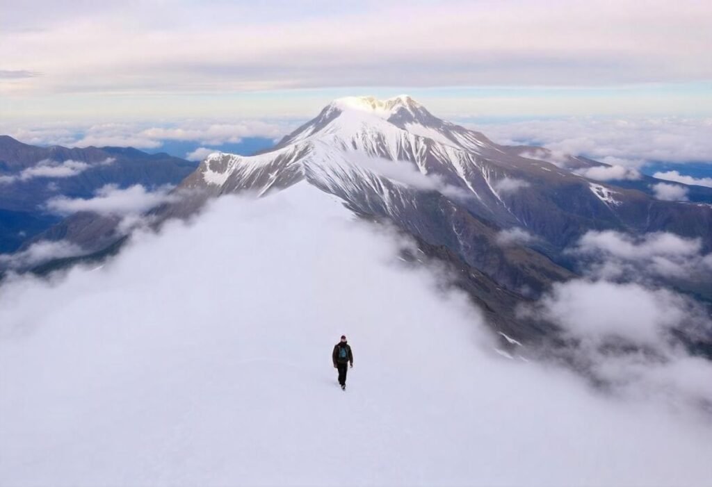
The last leg of the Mount Raung adventure is the most thrilling. The knife-edge ridge makes hikers go through a thin track up to the level of the crater wall, where only the best trekkers can have their heart in their mouth. One slip can be disastrous; therefore, this part does not only entail physical balance, but also iron nerves.
But the trophy? Absolutely breathtaking.
You are on top of one of the largest and busiest craters in Indonesia, with a wide-angle view of the East of Java. It is even possible to see some mornings mostly clear, mountains of volcanic mountains like the Mount Semeru, Mount Ijen, or even the Mount Agung in Bali, far away, both in the distance. Below you is the molten crater, which is reeling and churning- a blazing testimony of the power of the mountain.
The hiking part is not advisable for novices or persons with a phobia of heights. A local guide with the corresponding license who is a resident of the land would also be needed, as weather can change rather rapidly,y and there is no mobile connection.
Check Out: Dieng Plateau Hiking Guide: Top Tips for an Unforgettable Adventure.
Which Route Should You Choose? Trail Options and Difficulty Levels
The selection of the route in order to climb Mount Raung is important because the terrain is extreme, as well as the remoteness of the volcano. There are two main routes, which are the Sumberwringin Route and Kalibaru Route, respectively, which offer different kinds of experiences in terms of difficulty.
The most visited and developed route is the Sumberwringin Route, which usually amounts to the choice of local and international adventurers. In physical terms, it is an intense hike with steep hills, sharp volcanic paths, and a high altitude, which makes it intense and exhaustive, demanding much endurance. The advantage is that it allows one to get directly to the crater rim, and it is logistically a bit easier (when permits are available, and there are guides and porters).
The other route is the alternative Kalibaru Route, which is rather more out of the way and more off the beaten track. It is a more remote and more detailed experience in the wild; though, a more challenging one, as less infrastructure, including trails, is available, requiring spending more time hiking. As a case in point, when you happen to be a professional hiker and want to adventure on a less-traveled adventure path, then Kalibaru might provide you with the most desirable choice.
Those newbies/hikers on a time budget would little avail to visit Kalibaru, so much to do on the shorter, but no less dramatic Sumberwringin.
Best Time to Conquer Mount Raung
There is always an appropriate time to climb Mount Raung when hiking in Indonesia during the dry season, June to September. The month is also regarded as fairly clear and less demanding hiking routes at this point, and viewing is most of the time at the peak of a mountain, ready to give you a memorable panoramic scenery.
The hike in the rainy season (October to April) should be avoided so that travel on the trail would be risky. The volcanic rocks are no longer slippery, the rule of the landslides exists and heavy fog creates the situation even more dangerous at this time. Other than this, the crater rim is particularly vulnerable in wet weather as it is narrow and open.
To reach the summit in time so that it can get light (the sun is coming up) is at 2.00 to 3.00 AM. This leaves ample chance to head to the rim at dawn to observe a really spectacular sunrise over the volcanic scenery of East Java.
What to Pack for a Safe and Successful Mount Raung Trek
This is the reason why everyone must prepare when going to climb a mountain as challenging as Mount Raung. The terrain is remote, mountainous, as well as open, and having the right equipment in one bag is the line between a fun yet secure exploration and a dangerous experience.
Above all, wear hard hiking shoes that will give purchase on volcanic loose stone. Wearing o helmet is also strongly recommended, depending on the rocks that may fall off, especially near the crater. Even gloves, a headlamp, and thermal clothes matter since at night, it is very cold, especially in the level above 2,000 meters above sea level.
Be sure to take sufficient water, eat food that has high energy, and wear a windproof jacket that will fend off the gusts at higher altitudes. One can also carry trekking poles to complement the steep descent to prevent wearing the knees down, and a GPS unit or offline map is necessary in case one loses the way. Additions like emergency stores like a package of first aid kit, a whistle, a space blanket, etc, could also be shared.
Because of the isolation, complexity of the route, it is mandatory, not optional, that you should engage a licensed guide. The guides are conversant with the conditions of the trail, weather patterns, and emergency measures, hence providing you with a safe and successful hike. Lastly, proper pre-hike fitness planning will ensure the body gets used to the long-distance walk, altitude, and tough conditions.
Conclusion: Mount Raung – A Volcano Trek Like No Other
Mount Raung is not another hiking location; it is a test of strength and courage, respect towards nature. Reaching heights of more than 3,300 meters and sporting one of the greatest active craters of Indonesia, this giant in East Java is literally a once-in-a-lifetime and done experience: with its sheer adrenaline, volcanic beauty, and a panoramic view that is beyond reach.
But it is whether you are lured by the adrenaline rush of skinny ridges, or the status of being able to boast about having conquered one of the most difficult hikes in Indonesia, Mount Raung will provide you with an adventure of epic proportions if you are not afraid of it. However, it is not a path to mess with; good preparation, being physically fit, and having a dependable guide are what will make your journey safe and successful.
Mount Raung is probably the best (and craziest) climb you will ever make, providing you can manage it.
For more info: Click Here.
FAQs About Hiking Mount Raung
1. Can one visit Mount Raung as a starter hiker?
No, I would advise people to have experience with hiking or good physical shape to venture into Mount Raung. The steep paths, rocky ridges, and exposure close to the crater demand stamina coupled with mental strength.
2. What is my need for a guide to climb Mount Raung?
Of course, it is necessary to hire a local certified guide. The paths are tough, isolated, and at times complicated. Having a guide also ensures you are safe, and assists in logistics: visas, route choices.
3. Steep Cost: What is the procedure to camp overnight on the top of Mount Raung?
Most treks are 2-3 days with one or two nights camping on the mountain, yes. Campsites tend to be simple, so make sure you have good gear to keep you dry and warm at night.